Thracian era – Antiquity
Nebet Tepe
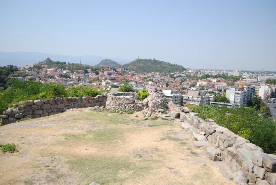
The oldest part of the city — here the Thracian settlement of Eumolpias was founded, later the acropolis of Philippopolis. Walls and towers survive from the 4th c. BC (cyclopean masonry), a 6th-c. Byzantine postern tunnel (under Justinian) and a large cistern. The site reopened to visitors in 2025 after restoration.
Story of the place
How to read this place
Nebet Tepe is where Plovdiv began. On the northernmost of the Three Hills the Thracians raised the settlement of Eumolpias at the end of the 4th millennium BC, and after them every power — Macedonian, Roman, Byzantine and Ottoman — left its mark on the same fortified summit.
- Founded
- c. 4000 BC
- Cistern
- ≈ 350 m³
- Reopened
- 20 March 2025
The first city
The first settlers appeared on the hill around 4000 BC. Later the Thracians founded Eumolpias here — one of the oldest settlements in Europe, continuously inhabited ever since. Earlier sources called the rise “the hill of Musaeus” after the mythical companion of Orpheus.
Source trail: Wikipedia — Nebet Tepe ↗Walls of every empire
The oldest fortifications date to the 4th century BC — massive cyclopean masonry of syenite blocks fitted without mortar, with an imposing quadrangular western tower. As the town grew under Macedonian rule the summit became the citadel. The Romans added a bastion in the 1st century AD (uncovered in 2016 excavations), and in the 6th century, under Justinian, a secret postern passage with a staircase was cut under the north wall down to the Maritsa river.
Source trail: Wikipedia — Nebet Tepe ↗What survives
Visible today are the cyclopean ramparts, the quadrangular tower and the postern passage. In the southern sector a large rectangular cistern of about 350 m³ survives, built of alternating layers of stone and brick with its walls and floor coated in a hydrophobic plaster.
Source trail: Wikipedia — Nebet Tepe ↗The acropolis today
The name comes from the Turkish “nevbet” (guard) and “tepe” (hill) — “the hill of the guards.” Its terraces command a panorama over the whole city. After restoration under the “Along the Fortress Walls of Philippopolis” project the site was officially opened to visitors on 20 March 2025 and is managed by the Regional Archaeological Museum — Plovdiv; it is a cultural monument of national significance.
Source trail: Wikipedia — Nebet Tepe ↗Dating
Thracian era – Antiquity
Source trail: Wikipedia — Nebet Tepe ↗Architect/builder
not identified in the current public source
Source trail: Wikipedia — Nebet Tepe ↗Current status
Publicly documented historic site; detailed visiting status still needs verification.
Open map ↗Public Wikidata record
mountain in Bulgaria
- Type
- hill and fortress
Traces and evidence
-
Description and historical context for Nebet Tepe.
Source trail: Wikipedia — Nebet Tepe ↗ -
Coordinates for Nebet Tepe.
Source trail: Coordinates (Wikidata) · Nebet Tepe ↗ -
Media and license for Nebet Tepe: View from Nebet hill, Plovdiv, Bulgaria.jpg.
Source trail: Wikimedia Commons — View from Nebet hill, Plovdiv, Bulgaria.jpg ↗
Current status
Publicly documented historic site; detailed visiting status still needs verification.
Ownership, care and institutions
The public record used here does not identify a traceable ownership or management history. This page therefore shows only verified institutional and source links.
Connected people
No people are linked in the current knowledge base.
Visit and orientation
- Coordinates
- 42.15124, 24.75218 · wikidata_coordinate
- Built/date
- Thracian era – Antiquity
- Architect/builder
- not identified in the current public source
Full event stream
All 1 linked events are grouped by record type.
historical_timeline 1 records
-
Nebet Tepe’s long settlement sequence
Municipal visitor sources place the earliest traces at Nebet Tepe between the Neolithic 6th millennium BC and the 4th millennium BC. Its layers show a settlement sequence spanning millennia, rather than one uncontested founding date.
Around this place
Connected places show that this site works as part of a wider urban system: The Seven Hills (tepeta).
No separate archive or then/now record is available for this place yet. The main image, coordinates and sources remain published.