4 min read
Before Plovdiv: How a Settlement Climbed to the Hills
From the Neolithic settlement at Yasa Tepe to fortified Eumolpias and the conquest by Philip II, Plovdiv's earliest history is a story of movement toward higher ground.

Chapter 01
The Hills Before the Skyline

In the photograph from 1892, Dzhambaz Tepe is already covered with houses, its slope rising above the lower city. The rocky dome looks like a natural pedestal, but it belongs to a larger group of syenite hills that reach roughly 250 metres. They give Plovdiv a silhouette that can be recognized before any individual building comes into focus.
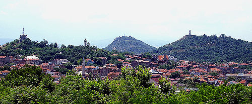
Six of the celebrated seven hills survive today. Markovo Tepe was quarried away during the twentieth century, while the others still divide, guide and gather the streets around them. Before there was a city called Plovdiv, the terrain had already determined where a person could see far across the plain—and where a settlement might become a defended centre.
The hills as skyline and lookout

Chapter 02
An Older Beginning at Yasa Tepe
The earliest known beginning is not found in the postcard view of the Old Town. Between 6000 and 5000 BC, Neolithic communities were already living in the area of present-day Plovdiv. Among the best-studied traces is the settlement mound of Yasa Tepe in today's Lauta district—well beyond the romantic idea that everything began on the Three Hills.
That distinction changes the story. The wider landscape was inhabited first; only later did a political and fortified centre gather on higher ground. The city did not appear in a single moment. It grew from repeated choices about where to live, and the movement toward the hills marks the passage from an early settlement to a place that could be defended and governed.
Chapter 03
Eumolpias Takes the Three Hills
By the fifth century BC, a fortified Thracian settlement known as Eumolpias or Eumolpeida stood on the Three Hills. With the rise of the Odrysian kingdom, the settlement and its surroundings entered a wider political world. Height was no longer merely convenient ground on which to live: it enclosed a centre from which the plain could be watched and the approaches guarded.
Here, scattered traces of human presence begin to resemble an urban biography. A name identifies a community, a fortification draws a boundary, and the hills bind the two together. Eumolpias is not simply an earlier label for Plovdiv. It marks the point at which the place belonged to the political world of ancient Thrace.
The fortified core of Eumolpias


Chapter 04
The Stone Summit of Nebet Tepe

At Nebet Tepe, the shift toward a fortified city can be read in the masonry itself. The oldest surviving defences date to the fourth century BC: large syenite blocks were fitted without mortar, and a quadrangular tower guarded the western side. The fortress was not an ornament on the hill. It turned natural height into an organized place of authority and defence.
Later eras did not abandon that choice. A Roman bastion, a sixth-century passage beneath the northern wall, and a large cistern holding roughly 350 cubic metres accumulated on the same summit. Each addition reused the advantage earlier inhabitants had already recognized. Nebet Tepe preserves not one frozen antiquity, but a succession of decisions to fortify and adapt the same ground.
Passage and prospect from Nebet Tepe


Chapter 05
342 BC: Conquest and a New Name
In 342 BC, the forces of Philip II of Macedon captured the fortified town. It became known as Philippopolis, and its stronghold offered a base for further Macedonian expansion into Thrace. For the inhabitants this was a sharp political change; for the hills, it was another ruler recognizing their value.
The new name carried the victory into the city's identity. It did not erase the earlier Eumolpias, but covered it with a new authority and a new memory. Plovdiv would acquire other names in later centuries, yet Philippopolis endured because it joined a military conquest to the emergence of the fortified Thracian centre as a city operating on a larger political scale.
Philip II and the city that took his name


Chapter 06
What the Hills Remember
Today the Old Town spreads across Nebet, Dzhambaz and Taksim Tepe. Houses, streets and later monuments conceal parts of the ancient centre, but they do not alter its basic form. From Nebet Tepe the plain is still visible—the same broad landscape that connects the early settlements, the Thracian stronghold and the expanding city.
Plovdiv's earliest history is therefore not a contest for one founding date. It begins with life across a wider landscape, climbs toward the defended hills, and continues through every authority that chooses to build on them. The names change; the rocky terrain remains an active part of the city.
The surviving hills in the modern city


Continue with another story
4 min read
Medieval Plovdiv: The City Behind Hisar Kapia
One gate, two major reversals and centuries of reused walls reveal why Plovdiv remained a coveted stronghold between Bulgaria, Byzantium and new powers in the Balkans.
4 min read
The Maritsa After the Flood: Bridges to the 'Opposite Shore'
The 1957 flood left more than 10,000 Plovdiv residents homeless. Old views of Gerdzhika and bridges from 1960 and 1977 show how the city joined its banks without making the river harmless.
4 min read
Old Plovdiv as Project: Restoration, Administration and Memory
In 1969, Plovdiv created a dedicated administration for the Old Town, turning the care of Revival houses from isolated repairs into long-term civic work.